

Photo Record
Images
Metadata
Object ID |
B190-006 |
Title |
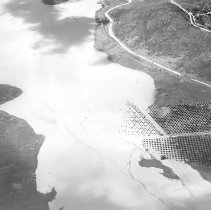
San Gabriel River flooding |
City File Number |
Complete File Number is B190-FloodRioHondoSanGabrielEtc-006 |
Description |
San Gabriel River flooding of farmland. More than six inches of rain fell on March 2, 1938 throughout Southern California, causing widespread flooding throughout Los Angeles County. Bridges were destroyed, highways sank, houses collapsed, and landslides were triggered throughout the city. From the San Gabriel Valley to the San Fernando Valley to the Pacific Palisades the existing storm control drainage was no match for the overwhelming downpour. (Complete File Number is B190-FloodRioHondoSanGabrielEtc-006) |
Date |
c. 1938 |
Place |
Azusa, California |
Collection |
Los Angeles City Archives Department of Engineering Historical Photos |
Provenance |
City of Los Angeles Engineering Department |
Cataloged by |
Sklar, Anna |
Copyright |
Los Angeles City Archives, City Clerk |
Photographer |
City of Los Angeles Engineering Staff |
Search Terms |
1938 Flood Azusa farmland aerial |
Subjects |
Rivers California Los Angeles Flood Control California Los Angeles Flood Control California San Gabriel Valley Aerial photographs Azusa (San Gabriel, Calif.) |